EINLEITUNG | DOKUMENTE | BILDER | LANDKARTEN | HERAUSGEBER
|
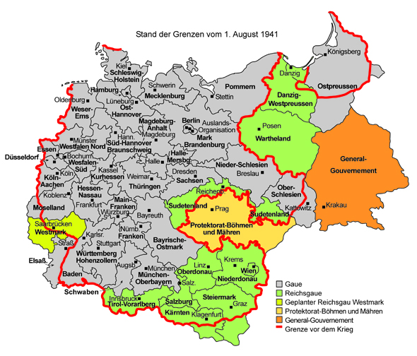
Auf dieser Karte sind die Gaue und ihre jeweiligen Hauptstädte eingezeichnet. Die ab 1938 an das Reich „angeschlossenen“ Gebiete wurden zu Reichsgauen erklärt und waren sowohl staatliche Verwaltungsbezirke als auch Parteigaue. An ihrer Spitze standen sog. Reichsstatthalter, die gleichzeitig auch Gauleiter waren. Die Karte zeigt die Reichsgaue, die bis 1941 auf österreichischem (Wien, Niederdonau, Oberdonau, Steiermark, Kärnten, Salzburg, Tirol-Vorarlberg), tschechischem (Sudetenland) und polnischem Gebiet (Danzig-Westpreußen, Wartheland) eingerichtet wurden. Diejenigen besetzten Gebiete, welche nicht in das Deutsche Reich eingegliedert wurden, bezeichneten die Nationalsozialisten als Generalgouvernement (Polen) bzw. Protektorat Böhmen und Mähren (Tschechoslowakei).
Klicken Sie auf Druckfassung (unten) für eine größere Version mit verbesserter Auflösung.
© Deutsches Historisches Institut, Washington, DC, 2008 |
 Druckfassung
 zurück zur Landkarten-Liste
 vorherige Landkarte